Update: This work was published in GRL! (Got a paywall? Here’s the preprint.)
Snow bedforms – such as dunes, ripples, and anvil-shaped sastrugi – cover as much as 11% of the surface of the Earth. They decrease the reflectivity of the surface, increase its aerodynamic drag, and change the way that wind-blown particles, like dust and sulfates, deposit on the snow.
These effects have the potential to change Earth’s climate. In order to include these effects in weather and climate models, however, we need to know where bedforms are.
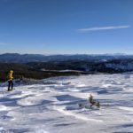
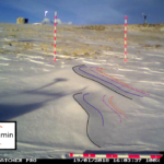
Field data
For the past three winters, I’ve documented the evolution of snow bedforms in the Colorado Front Range using time-lapse videos. You can see some of the observations below:
Building classifiers
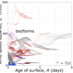
We used our observations, along with weather data from the Niwot Ridge LTER, to generate the first predictions of bedform presence as a function of time.
These predictions take the form of softmax classifiers. Each classifier explains the probability of a snow surface falling in a particuar category (e.g. “flat” vs “not flat”) as a result of one or more weather variables.
To make good predictions, we had to identify the most important weather variables. We therefore built ~450 classifiers using different combinations of weather variables, and selected the best for our results.
We validated the classifiers using bootstrapping.
Results
We found that (1) snow is never flat when winds are faster than 7 m/s or when the snow is older than 0.5 days, (2) the largest bedforms, sastrugi, are formed by wind speeds higher than 15-30 m/s, and (3) bedforms that reach melting temperatures cease evolving.
Read the whole study in ‘Statistical classification of self-organized snow surfaces’.